Florence Town Walls
Oltrarno District
Click here for more Photos - View A
Map of the Town Walls
 |
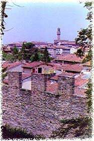
Medieval Florence was enclosed in curtain walls that
contained today's historical center. In the last century, restructuring
brought the city to be the capital of the Kingdom of Italy and the city
walls were demolished, with the exclusion of the gates.
The entire line
on the right bank of the Arno was replaced with the actual Avenues of
circumrotation. The part of city situated on the left bank of the river
Arno, called 'Oltrarno', still has notable traces of the city walls.
Today the goal of restructuring will bring the reopening of some lines
of the watch walk, from which it will be possible to enjoy a new vision
of the historical beauties of the city. The construction of the city
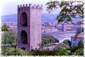
walls began on the 2nd of January 1285 , to replace the first fortified
line (1173-1175 ) since the city had expanded beyond the old walls. The
new enclosure measured 8500 meters, was endowed of 73 towers and 15 gates
and contained a surface of 430 hectares, equal to 5 times that of the
previous walls.
The greatness of the work was necessary to face the huge
demographic and city expansion. It's calculated that in the 1125 Florence
counted 25.000 inhabitants, in 1280 came to 80.000 and already grazed
100.000 in the first years of the 14th century. This building entourage
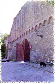
was planned to be one of the largest, most powerful and most heavily
defended of the time. In fact they became one of the most formidable
city walls of medieval Europe. These walls at many places were endowed
with a ditch fed by the waters of the Mugnone, a small tributary of the
Arno, whose waters raced had been diverted for that purpose. Construction
was not finished until 1333 because wars interrupted the work several
times. The 'Magister Murorum' (Architects) responsible for designing
the walls included Arnolfo di Cambio, Giotto and Andrea Pisano.
|