Rocca of Saturnia
 |
Saturnia, famous for its sulphur springs, is located in the municipalità of Manciano, and can be reached by the principle city Grosseto or via Scansano by following the street signs.
 The ancient nucleus of Saturnia rises on a rocky
plateau on the left bank of the Albegna river where it meets with the Stellata
stream. The existence of the settlement was documented in the 12th
century as the location of a country church and an already well known thermal
bath resort, even though it had already been an Etruscan
center (near
the Etruscan necropolis Pian di Palma) and a Roman center
(built along the Via Clodia).
The ancient nucleus of Saturnia rises on a rocky
plateau on the left bank of the Albegna river where it meets with the Stellata
stream. The existence of the settlement was documented in the 12th
century as the location of a country church and an already well known thermal
bath resort, even though it had already been an Etruscan
center (near
the Etruscan necropolis Pian di Palma) and a Roman center
(built along the Via Clodia).
 In 1170 the castle was under the control of the Counts
of Tentennano, from 1216 under the Aldobrandeschi, and later passed under
the control of the Conte Bonifacio di Santa Fiora. In 1274, with the
fall of the Aldobrandesco feud, Saturnia became part of the Sovana country.
It was pillaged by the Sienese in 1299 and then again by the Orvietans in 1313 who ended up occupying it.
In 1170 the castle was under the control of the Counts
of Tentennano, from 1216 under the Aldobrandeschi, and later passed under
the control of the Conte Bonifacio di Santa Fiora. In 1274, with the
fall of the Aldobrandesco feud, Saturnia became part of the Sovana country.
It was pillaged by the Sienese in 1299 and then again by the Orvietans in 1313 who ended up occupying it.
In 1328 Saturnia passed under the control of the Baschi family and later to the Orsini. Siena then controlled it, but only temporarily in 1389, but not being able to control the town, they destroyed in in 1419 when it became a hiding place for those escaping the Republic. In the following years it was decided to build a keep and surrounding walls and to move a certain number of families, and others who came from the Romagna and Lombardy. Saturnia remained under the Sienese until it submitted itself to Cosimo de’ Medici in 1559. It was a feud of the Marquis Ximenes from 1593 and then the Panciatichi family from 1738.
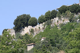
 Still today, the urban
structure of the medieval and
renaissance village is easily identified, having been built on the remains
of the ancient Roman colony from the 2nd century BC. Even the surrounding
walls, rebuilt by the Aldobrandeschi and then by the Sienese between
1454 and 1464 using craftsmen from Lombardy guided by the architect Luca
di Bartolo da Bagno, preserve large tracts of the Roman structure.
Still today, the urban
structure of the medieval and
renaissance village is easily identified, having been built on the remains
of the ancient Roman colony from the 2nd century BC. Even the surrounding
walls, rebuilt by the Aldobrandeschi and then by the Sienese between
1454 and 1464 using craftsmen from Lombardy guided by the architect Luca
di Bartolo da Bagno, preserve large tracts of the Roman structure.
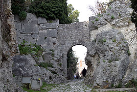
The gates, originally four, were placed according to the two axis Decuman and Cardus, but unfortunately the only one left intact is the Roman Gate to the south, with a nice arch on shelves reinforced by a second arch on the front interior. A trace of the Via Clodia passed through this gate and eventually through Roselle and Vetulonia reaching the Via Aurelia in an area called Salebro.
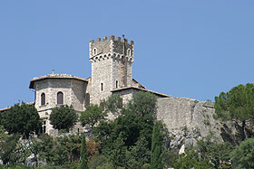
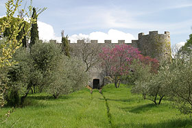 Right near
the Roman Gate (on the north-west corner
of the walls) rises the fortress, partly built in the surrounding walls
and bordered on the north-west by a stong, stone wall with a wide bastionated
base, reinforced by two round towers on the corners. The
walls present various arrow slits and battlements, which are partly original.
Right near
the Roman Gate (on the north-west corner
of the walls) rises the fortress, partly built in the surrounding walls
and bordered on the north-west by a stong, stone wall with a wide bastionated
base, reinforced by two round towers on the corners. The
walls present various arrow slits and battlements, which are partly original.
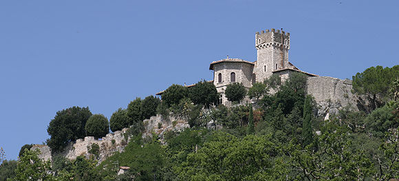
The structure was built during the rule of the Aldobrandeschi between the 12th and 14th centuries but was reinforced and enlarged during the Sienese rule in 1410. In the interior of this vast enclosure of about one acre, in 1929 the Ciacci family built a castle in neo-medieval style with crenelated towers that are reminiscent of the original complex.
| Back to Homepage |
| Back to Castles Index |